Resolution criteria
This market will resolve YES if, in any month of 2026, Ukraine’s net territorial gain in the Russia-Ukraine conflict is greater than zero square kilometres according to two or more of the following sources:
This market will otherwise resolve NO.
Clarifications
This market concerns de facto territorial changes. Territory gained or lost by diplomatic means (i.e. in a peace treaty) will be counted in this market, as well as territory gained or lost militarily.
For the purpose of this market, Ukraine’s net territorial gain can be understood as equal in magnitude and opposite in direction to Russia’s net territorial loss in the Russia-Ukraine conflict.
I will not trade in this market.
Update 2026-05-07 (PST) (AI summary of creator comment): The creator has identified two unresolved issues regarding potential YES resolution based on April 2026 data:
ISW infiltrations: ISW's May 2 report provides two figures — one including infiltrations (net gain for Russia) and one excluding them (net loss for Russia). The creator tentatively leans toward including infiltrations as the default, based on historical consistency, but has not made a final decision.
AFP as independent source: AFP's April analysis is based on ISW data. The creator is uncertain whether AFP and ISW should count as two separate sources for resolution purposes, noting that resolving on ISW data alone may be contrary to the market's intent, even if technically arguable.
No concrete resolution decision has been made. The creator is soliciting arguments on both issues.
 1,000
1,000People are also trading
@a_l_e_x while I still think this should have resolved a month ago based on the market resolution criteria(understand but don't agree with the claim of non qualification of non primary verification sources/analysis). We now also have Black Bird Group, Reuters, DeepState, Al Jazeera, AP, and others making the call of Ukraine Gains. Links:
Ukrainian strikes set off fires at oil facilities in Russia and Crimea
On Springtime Battlefield In War's Fifth Year, Ukraine Claws Back Territory
Ukraine reclaims territory as it doubles attacks on Russian logistics
@ShaneBo ok just had time to read through these:
DeepState, the New York Post and Al Jazeera are not resolution sources - I trust this is clear from the resolution criteria
the Reuters article is careful to report Syrskyi's estimate as a claim, not as fact. ("Reuters was not able to verify the assertions.")
you may need to point me to the relevant sentence/para in that AP article. Maybe I'm stupid/tired but I'm not seeing it
Black Bird Group reported a net territorial loss for Russia in February (and net gains in each month since). If you can find a second source on the list backing that up for February, then we can resolve YES.
Going back to April, you actually did convince me that ISW showed a preference for the "excluding infiltrations" figure that month and I'm happy to count it towards a YES resolution for April...
...which means the only remaining issue is whether that AFP article counts as a second source for April. Max is quite insistent that it shouldn't, and his argument is not without merit. I'm currently surveying other Manifold users whose opinions I value on how they would interpret the resolution criteria, and I'll defer to the majority.
Of course, the way things are going, we may have a clear-cut YES resolution soon anyway
@MaxA and ISW has done the same thing again...
I have to say I think Shane made some compelling arguments earlier. Would you still object to a YES resolution for April?
@MaxA understood. That was certainly my intention when I created the market, but I'm not sure I communicated that intention clearly enough. If there's no clear-cut YES resolution for May, I think I'll do what I suggested earlier and ask some impartial Manifolders how they would interpret the resolution criteria
@a_l_e_x As I noted in my other comments, and to add some additional thought to it: I'm not sure how a trader could intuit from the resolution criteria that specific intent particularly when you have three news wire services( I didnt mention earlier) in your resolution sources.
These news wire agencies are clearly very different from the other sources you have, but Each does do independent work and it's meaningful when orgs like AFP that pride themselves on independence and objectivity decide to put their weight and interpretation/fact checking to say that we have our team on the ground/expert verification and from all that we have seen this (from ISW) is what we deem as most accurate of the situation at hand. IF not a true primary source it is true primary reporting and stands on it's own. A reading of the articles from AFP notes that they considered things beyond ISW, interpreted and verified their data, etc. But even on it's own the verification on it's own is a signal
I get it's not as serious, that some might lump AFP into a new aggregator(I think this is wrong, as news wires are not just aggregators they do verification/fact checking/have people on the ground) and how much independent analysis took place is perhaps questionable, but I think there needed to be more clarity in the criteria if you are going to fully discount a listed source and likely two others AP and Reuters.
@MaxA NO? I agree with you that there particular teams are not doing all of the same things as some of the other sources, but I don't understand an argument for a flat no to independent work. Would you say if a news agencies has a team of people who are trained to verify satellite imagery, do fact checking, compare on the ground reporting, etc that if they include information from other sources they are by default not independent?
@ShaneBo A simple counterfactual: without ISW or another team like it, AFP or Reuters would not be able to report the numbers we care about in this question.
@MaxA I get your points and understand the intent your explaining. THey do heavily utilize the information from them which includes perhaps nearly all or all of the key data that reflects areas of control/territory gain/loss . BUT they do all have large teams on the ground https://www.afp.com/en/agency/inside-afp/inside-afp/ukraine-year-unprecedented-coverage-afp-0 and that information(from other sources ) is being packaged and interpreted in the context of their independent reporting outside of this specific data, independently fact check/ verified by their team, and an independent decision is made to weight that data above other sources. ALL said all these sources were included in the resolution criteria without caveats.
@ShaneBo As soon as we see any monthly control numbers from AFP that won't refer to ISW or any other listed group as the original source, I'll be with you. Until then - they are not a true second source.
AFP Confirms Ukraine Gains
The Moscow Times: Russia Lost Ground in Ukraine in April, a First Since Mid-2023 – AFP Analysis
SpaceWar.com: Russia lost ground in Ukraine in April, a first since mid-2023: AFP analysis
Japan Today: Ukraine and Russia declare separate truces (includes AFP territory data)
ISW Confirms Ukraine Gains:
Primary ISW Report: Russian Offensive Campaign Assessment, May 2, 2026
Monthly Data Summary: The Russia-Ukraine War Report Card, May 6, 2026
Weekly Data Snapshot: The Russia-Ukraine War Report Card, April 29, 2026
@ShaneBo thanks for bringing these to my attention. There are two thorny issues here:
Firstly, the ISW report you linked shows a net gain for Russia with infiltrations included and a net loss with infiltrations excluded. I've never seen ISW provide two different figures like this, so which should we use?
Previously, ISW seems to have included infiltrations in net territorial changes. The monthly figures for November to March in the March 31 report match the "including infiltrations" figures in the May 2 report, which leads me to think including infiltrations should be viewed as the default, and excluding them is a novelty. But I could be convinced otherwise.
The second issue is that the AFP analysis is "based on ISW data" and not an independent estimate. Should we treat these as two distinct estimates when they are, effectively, coming from the same source?
This is really my fault for not anticipating a foreseeable problem. With the way the resolution criteria are phrased, I think you have a strong argument that these should count as two instead of one, but resolving solely on ISW data does seem contrary to the clear intention of the market.
Btw, nothing I've said here represents a concrete decision and I'm keen to hear arguments (from you or anyone else) on both issues
@a_l_e_x you have the classic letter vs spirit conflict. Your original criteria were clearly built to have a solid confirmation of Ukrainian gains. Now you have a situation where they are failing. And we know that at the same time all other trackers are showing Russian gains, albeit smaller than before. The spirit of the question suggests there's no YES yet. Based on the exact wording, there's a YES if you choose to accept the ISW change.
If this were Metaculus, they'd most likely annulled the question. Here you're making the decision.
@MaxA @a_l_e_x A few points to my argument I'll lay out here:
@MaxA I disagree a bit on the letter vs. spirit conflict. I'll argue below that ISW identifying and removing the infiltration data is providing a source that more accurately tracks territorial control.
If the market's spirit was to track which side is "winning" ground, Control is the most objective/standard metric. Including infiltrations introduces "noise" from transient movements that often disappear within 24–48 hours. The fact that ISW explicitly broke out these figures for the first time in May suggests they recognized that the "Total" figure was masking a significant shift in actual control dynamics.
The inclusion of infiltrations in previous reports was a limitation of the data available at the time. By providing a breakout in the May 2 report, ISW is effectively 'cleaning' their data. To resolve on the 'Infiltration' figure is to treat a temporary scouting party as equal to an established defensive trench line. AFP's recognition of this suggest an additional credentialed acknoledgement that this is the most accurate data concerning actual territiorial control. Other sources not included in this collection are agreeing, and others are holding off their usual announcements as they consider this advancement. ALL to say that I would argue that this resolves yes both in spirit and by the letter
ON ISW and AFW sharing I get this point but:
ISW provides the raw spatial data. AFP performed its own independent analysis of that data to reach a net square-kilometer conclusion.
AFP is an independent entity with its own fact-checking and editorial standards. Their decision to headline the "Net Loss" figure constitutes a distinct, professional confirmation that the data supports a "YES" outcome.
I think this is of course also defensible by the letter: If the criteria say "If a major tracker/agency reports a net gain/loss," and both ISW and AFP have published headlines/reports stating exactly that, then I'd argue the "spirit" is irrelevant. Maybe particularly more so in this case because we have a very specific set of sources versus a broader range where you might be able to get more into the spirit debate. The criteria have been met. However, as I argued above I do think the spirit has been met
Summary of Thoughts: On Infiltrations: We should prioritize the 'Excluding Infiltrations' figure because 'Control' is the only metric that satisfies the common-sense definition of 'territorial gain.' Infiltrations represent presence in a gray zone, not control. The fact that ISW felt the need to break this out for the first time in May suggests they viewed the 'Control' metric as the more accurate representation of the month's reality. Resolving on 'Infiltrations' essentially credits 'scouting' as 'possession.' Some sources are beginning to shift to this and are actively debating it, but seems to me the most legit sources are begining to favor the infiltration exclusion
On AFP: While they use ISW data, their analysis is independent. AFP didn't just retweet ISW; they performed a net calculation and applied their own editorial standards to verify the '120 sq km' figure. In OSINT, we rarely have independent primary data (most use the same satellites); independence is found in the analysis of that data.
If the criteria require a major agency to note a gain, AFP has done exactly that in a headline. Following the literal text of your criteria leads to a 'YES' resolution.
@BodeyBaker Yes. With the proliferation of drones, the whole concept of zones of control is beginning to lose its meaning. The line of contact these days is small teams sitting in trenches or basements, with both sides' drones flying overhead. The soldiers can't go above ground freely, so they can be living with an enemy's team living in another trench a thousand feet behind their backs, not knowing that and having no means to do anything about it.
@ShaneBo It's in response to Alex saying this:
Firstly, the ISW report you linked shows a net gain for Russia with infiltrations included and a net loss with infiltrations excluded. I've never seen ISW provide two different figures like this, so which should we use?
Sorry for not quoting
@MaxA @BodeyBaker @a_l_e_x thanks Max for the clarification and for including the point on drones. I think the drone induced change in control mechanics is a big part of ISWs change in how they view things, and more accurately captures the reality of the situation. I'll add what I hope brings some additional clarity to my previous argument that takes note of the drone reality:
While "including infiltrations" may have been the previous default, that was an artifact of lower-fidelity data. Now, ISW has better visibility. To use an outdated, noisier metric when a cleaner one is provided is I think a choice to prioritize inaccurate history over current reality. As Max notes drones have fundamently shifted what accounts for control and infilitrations aren't really controlling anything
AFP specifically chose to highlight the "Net Loss" figure. If a major world news agency (AFP) and the primary data provider (ISW) both agree that "Control" has decreased, that is a double confirmation by the letter of the law.
The spirit of a "territorial gain" market is to see if the map is moving. If Russia is "gaining" by sending people into basements where they are immediately pinned and unable to be resupplied, but losing their established defensive lines elsewhere, that is a net loss of power and territory.
I argue that ISW and AFP have simply caught up to this reality by excluding "infiltrations" from their confirmed control tallies. Many other sources are begining to do the same
@ShaneBo We're looking at the change from month to month. The Ukrainian gains only exist in ISW data if the absolute value of the area under control as of the end of March calculated using the old system is compared to the same as of the end of April calculated using the new system. So, basically, apples to oranges. And infiltrations didn't suddenly change qualitatively during April - the fuzziness of the LOC has been an issue for many months (I can give you multiple links to DeepState's Telegram and YouTube channels discussing that problem).
So, I think the optimal approach would be to take the delta of the "inclusive" ISW April data to the ISW March data (implicitly "inclusive"), and then use the deltas for "exclusive" statistics for April to May, May to June etc.
It should be noted that both Shane and I are arguing in favor of the positions we're holding here.
@a_l_e_x @MaxA I think I track the core of the debate here. Max, your point on drone ambiguity I think actually strengthens the case for excluding "infiltration" data: it supports the argument that the ISW and AFP sources are matching not only the letter but the spirit of the market by tracking physical control over transient presence. I'm curious if we agree on that, and are just debating how we assess the change in methodology as it relates to this markets specific resolution?
However, to address the methodological "apples to oranges" concern specifically, we can look at the data continuity. The net loss is not a statistical artifact of the May 2nd methodology shift; it is a physical reality that was already being recorded in the "old" system.
The March 31/April 29 ISW-Russia Matters Report Card used the standard reporting system and already showed a negative delta for Russia before the formal "Infiltration Layer" was even introduced:
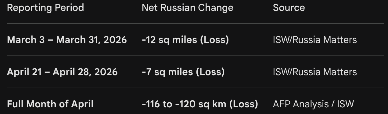
"During the prior four-week period (March 3–31, 2026), Russia suffered a net loss of 12 square miles. In the shorter term, Russia lost 7 square miles (net) during the past week (April 21–28, 2026)... according to ISW data."
— Source: The Russia-Ukraine War Report Card (Russia Matters/ISW), published April 29, 2026.
This proves that the April net loss is a physical reality on the ground, not a result of "re-categorizing" old territory in May. The "Infiltration" layer didn't create the loss; it simply provided the technical explanation for the delta between what the Kremlin was claiming and what they actually held.
The market resolution criteria explicitly state:
"This market will resolve YES if, in any month of 2026, Ukraine’s net territorial gain... is greater than zero square kilometres according to two or more of the following sources."
We have exactly that:
ISW: Explicitly noted a "net loss of territory controlled" for April 2026.
AFP: Performed an independent net calculation and made the editorial decision to headline it as a "Russian Loss."
To reinforce the two source assessement. In OSINT, independence is found in the analysis, not the raw satellite data (which everyone shares). AFP's choice to validate and publish these specific figures fulfills the requirement for a secondary source.
Bottom line: I don't think we should discount the assessement because the primary tracker became more precise. The criteria have been met both by the literal text and the operational reality of the front line. I stand by this being a clear yes
Max, let me know what you see some faults or missing info here.
@ShaneBo In this situation, AFP is not a primary source. They're just doing basic math on ISW data. Anyone following these trackers knows that every one of them invests a lot of effort into independent data collection, and when the data has been collected, its analysis becomes just basic middle-school geometry calculations. So, even if we ignore the change in methodology and whether it's a better reflection of the conditions on the ground, a YES based on AFP and ISW would be a resolution on pure technicality, just because the author incorrectly assumed that all listed sources would be independent.
I think your misunderstanding of the nature of this work most prominently shows when you apply the OSINT label to it. While a large portion of the sources are classical OSINT like the videos by Madyar, Rubikon, or other Telegram channels of AFU units or Z-influencers, there are many steps that need to be made before there's any data that's good enough to be analyzed, and sourcing for those steps comes from the places that are the opposite of open - and are definitely not satellite maps. I can't say much about the Russians, they're too icky for me to follow closely, but the same DeepState has done plenty of deep dives on their processes, and those talks make it obvious that these guys are not OSINT, at least, not anymore. I'm telling you this as someone who worked with one of the most prominent Ukrainian OSINT groups in the first years of the war in Ukraine. DeepState's or ISW's capabilities far exceed those available to the nerds who spent their days scrolling through Odnoklassniki in search of careless selfies. These are the teams doing the hard work, and AFP appears to have just glommed onto it.
@ShaneBo okay, I think your comments are partly AI-generated but there are some points worth discussing and I've written my thoughts below. I'm still not convinced either way, so if this continues to be disputed I might try to assemble a panel of trusted Manifolders (probably mods) to help me decide both issues
On issue 1:
The inclusion of infiltrations in previous reports was a limitation of the data available at the time. By providing a breakout in the May 2 report, ISW is effectively 'cleaning' their data.
No, ISW has clearly been able to include or exclude infiltrations since November at the latest and has chosen to include them as gains/losses. Is there any reason to think they've rejected that practice as inaccurate?
To resolve on the 'Infiltration' figure is to treat a temporary scouting party as equal to an established defensive trench line.
This is a stretch. It is entirely possible to control an area without trenches, fortifications, etc. But I think you have a fair point here.
AFP's recognition of this suggest an additional credentialed acknoledgement that this is the most accurate data concerning actual territiorial control.
In my view, AFP's use of the exclusionary figure suggests that it is more newsworthy, not necessarily more accurate for our purposes.
Other sources not included in this collection are agreeing, and others are holding off their usual announcements as they consider this advancement.
Who?
Infiltrations represent presence in a gray zone, not control. The fact that ISW felt the need to break this out for the first time in May suggests they viewed the 'Control' metric as the more accurate representation of the month's reality.
Ordinarily I would be inclined to agree that infiltration ≠ control (though I should point out that the word 'control' does not appear anywhere in the resolution criteria). But it's hard to ignore the fact that the standard practice of ISW itself has been to count infiltrations as gains. I don't really see how ISW providing both figures now suggests that one is more accurate than the other.
However, to address the methodological "apples to oranges" concern specifically, we can look at the data continuity. The net loss is not a statistical artifact of the May 2nd methodology shift; it is a physical reality that was already being recorded in the "old" system.
This is correct, but you've contradicted what you said earlier about ISW not having the data available until now.
On issue 2:
ISW provides the raw spatial data. AFP performed its own independent analysis of that data to reach a net square-kilometer conclusion.
ISW has done 99% of the work here by gathering evidence, making subjective decisions about who controls what (i.e. analysis) and displaying it all on a map. The full extent of AFP's "analysis" would have been to look at that map at the start and end of the month to calculate the net area that changed hands. This is why they reached virtually the same figure.
I could make a map of my backyard and shade the area covered by leaves, then send the map to someone on the other side of the world. We could both "independently" calculate the area covered by leaves, based on my map, and arrive at the same figure. But the other person hasn't seen my backyard and hasn't made independent decisions about what counts as covered.
In OSINT, we rarely have independent primary data (most use the same satellites); independence is found in the analysis of that data.
Satellites? ISW seems to rely mostly on Telegram posts and geolocated photos/videos from social media. But I fear I'm going off track.
Here's how I see it... ISW has done an analysis of the data. AFP appears to have done an "analysis" of ISW's analysis. I can't consider that a truly independent analysis. I think your stronger argument is that the resolution criteria don't explicitly require one.
On issue 1:
The inclusion of infiltrations in previous reports was a limitation of the data available at the time. By providing a breakout in the May 2 report, ISW is effectively 'cleaning' their data.
No, ISW has clearly been able to include or exclude infiltrations since November at the latest and has chosen to include them as gains/losses. Is there any reason to think they've rejected that practice as inaccurate?
My response:
I feel I made clear. They made a decision that this is actually the most accurate way to address the reality of control. Which I defined as the spirit of real territory gains or losses.
To resolve on the 'Infiltration' figure is to treat a temporary scouting party as equal to an established defensive trench line.
This is a stretch. It is entirely possible to control an area without trenches, fortifications, etc. But I think you have a fair point here.
My response: Sure, but I think I supported well enough in other analysis as to why this makes sense. But more importantly it is what ISW is suggesting makes sense
AFP's recognition of this suggest an additional credentialed acknoledgement that this is the most accurate data concerning actual territiorial control.
In my view, AFP's use of the exclusionary figure suggests that it is more newsworthy, not necessarily more accurate for our purposes.
My Response: An independent source putting their reputation behind it and agreeing to the logic seems to meet the criteria of a credenitialed validatation, but can cede that. In the end I just don't think it matters given your resolution criteria. They are one of your listed sources
Other sources not included in this collection are agreeing, and others are holding off their usual announcements as they consider this advancement.
Who?
Infiltrations represent presence in a gray zone, not control. The fact that ISW felt the need to break this out for the first time in May suggests they viewed the 'Control' metric as the more accurate representation of the month's reality.
Ordinarily I would be inclined to agree that infiltration ≠ control (though I should point out that the word 'control' does not appear anywhere in the resolution criteria). But it's hard to ignore the fact that the standard practice of ISW itself has been to count infiltrations as gains. I don't really see how ISW providing both figures now suggests that one is more accurate than the other.
My Response: I list the logic of this in my responses, and ISW also lists their logic and reasoning within their own reports. They are doing so for transparency and explicitly noting that the new way is more accurate. Max makes a great point regarding this with his drones input.
However, to address the methodological "apples to oranges" concern specifically, we can look at the data continuity. The net loss is not a statistical artifact of the May 2nd methodology shift; it is a physical reality that was already being recorded in the "old" system.
This is correct, but you've contradicted what you said earlier about ISW not having the data available until now.
My response: tI am referncing losses showing up in the old system
On issue 2:
ISW provides the raw spatial data. AFP performed its own independent analysis of that data to reach a net square-kilometer conclusion.
ISW has done 99% of the work here by gathering evidence, making subjective decisions about who controls what (i.e. analysis) and displaying it all on a map. The full extent of AFP's "analysis" would have been to look at that map at the start and end of the month to calculate the net area that changed hands. This is why they reached virtually the same figure.
I could make a map of my backyard and shade the area covered by leaves, then send the map to someone on the other side of the world. We could both "independently" calculate the area covered by leaves, based on my map, and arrive at the same figure. But the other person hasn't seen my backyard and hasn't made independent decisions about what counts as covered.
In OSINT, we rarely have independent primary data (most use the same satellites); independence is found in the analysis of that data.
Satellites? ISW seems to rely mostly on Telegram posts and geolocated photos/videos from social media. But I fear I'm going off track.
My response: this is an analogy not an analysis of methodolgy. It is supporting the ability of secondary sources to have their own independence not just primary sources.
Here's how I see it... ISW has done an analysis of the data. AFP appears to have done an "analysis" of ISW's analysis. I can't consider that a truly independent analysis. I think your stronger argument is that the resolution criteria don't explicitly require one.
My response: This is the main point of my argument, it matches your resolution criteria, but also has I think a fairly strong "spirit" argument that the way ISW is calculating losses/gains is the most accurate
@MaxA I can make a longer reply tomorrow, but I want to be clear that I am not suggesting AFP is a primary source. My argument isn't that AFP is "doing the hard work" of primary collection; it’s that for the purposes of a resolution contract, they are a designated analytical validator. The OSINIT mention is purely a reference to independence not rigor. They are listed as source and can make a decision using shared data. For the purposes of the market maybe it would be much better to only have primary sources, but that is not what is written.
@ShaneBo ON other sources the most notable is DeepStatesUA definition of gray zones which is perhaps looser than ISW on what constitutes control(territory gain/loss) as the infiltration will not count until some conditions have been met. Blackbird seems to be weighing on the fuzziness of the LOC as well,. Neither of these are fully in agreement with the specific assesment of control at this point, but their analyis seems clearly to support that infiltrations should be questioned.
@ShaneBo You are finally seeing my point:
"For the purposes of the market maybe it would be much better to only have primary sources, but that is not what is written."
Exactly what I've been saying all this time: spirit ("better to only have primary sources") vs letter ("but that is not what is written")
As for the gray zones and how each team defines it - irrelevant, as long as those definitions remain consistent month to month.
@MaxA I honestly think we mostly agree. Core contradictions is that I feel it’s possible to prove the spirit of the market by supporting just ISWs analysis and that though it may be best with primaries it doesn’t sufficiently weaken the core argument , and that at the end of the day for manifold the letter of the market is more important
To clarify: also noting that secondary sources have value and independence
@ShaneBo I tried and perhaps failed to make this clear in each of my comments. To make a spirit argument but prioritize how this market is written